Where did civilization begin? The four earliest known civilizations developed in fertile river valleys which explains some of the where and why of the beginning of civilization.
Lesson Plan Procedures
1. Introduce the four early river valley civilizations.
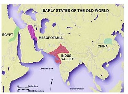
The earliest civilizations shared many common features. The most significant of these was that they grew out of farming settlements in river valleys. The four early river valley civilizations rose in Mesopotamia (modern-day Iraq), Egypt, the Indus River Valley, and the Huang He valley. These civilizations developed in the valley between the Tigris and Euphrates, along the Nile, the Indus and Ganges, and Yellow Rivers respectively. Understanding why proximity to rivers was important to the growth of cities will enable students to grasp the how, why and where of early civilization development.
2. Discussion Questions:
- What activity was the most important foundation of cities and civilization? In other words, which endeavor caused the growth of cities?
Agriculture. Farming began during the Neolithic Revolution as people began to plant seeds, grow their own food, domesticate animals and settle in villages. It was a slow process that occurred at different times around the world but can be dated as far back as 8000 BCE in the Middle East. The Neolithic Revolution also saw technological advances such as: the development of the plow and fertilization techniques, the invention of the loom and the wheel, the skill of baking clay bricks for building and hammering metals for weapons and jewelry, and the development of a calendar.
- Why was agriculture so important to the beginning of civilization?
It spurred the growth of cities. Civilization comes from the Latin word civitas which means city.
The development of agriculture allowed people to settle in one place, develop specialized skills, and eventually form governments. Cities grew from these settlements and systems of irrigation to support farming were developed. Overseeing large irrigation projects was one of the first functions of government.
- Agriculture and surplus crops allowed some people to stop farming and learn specific skills. Did this lead to the start of a system of trade?
Yes. Civilizations developed an economy. Economy can be defined as the means by which people’s material needs are met through the use of their environment.
Agriculture led to surplus food so some people began to earn a living doing other things besides farming. People became metal workers, merchants, traders, and priests. Trade and commerce led to a need for record keeping which led to systems of writing and the new occupation of scribe .
- What were people with specialized skills called?
Artisans. These were people who could create and make the goods needed to live and work.
Use the following map assignment to develop Social Studies skill and learn the meaning of the terms latitude, longitude, meridian and parallel.
-
Discuss and define the terms latitude and longitude.
- Lines of Latitude (parallels) run east and west and measure the distance north and south of the equator. The equator is at 0 degrees and each line of latitude is 1 degree (69 miles or 110 km) from the next line of latitude. It is listed first in a grid address.
- Lines of Longitude (meridians) run north and south between the poles and measure distance east and west from the Prime Meridian at 0 degrees longitude. They intersect at the poles and are not from equidistant from each other. Lines of longitude increase east and west of the Prime Meridian to 180 degrees.
-
Hand out copies of maps of the regions students will be examining. (Maps are in the media gallery- see below.)
-
Have students determine the approximate grid addresses for the following. Have them name civilizations that developed in these geographical areas and explain why these regions were conducive to the growth of the earliest cities.
-
The point where the Indus River meets the Gulf of Oman
-
The city of Baghdad
Lake Victoria.
Extension Activity
Ask students to name the largest or busiest city near your school.
Examine the location of this city on a map and discuss what geographical features may have influenced the growth of a city at that particular spot.
Standards Met:
NCSS Thematic Standard: VIII Science, Technology, and Society.
NSS-WH.5-12.1 ERA 2: Early Civilizations and the Emergence of Pastoral Peoples, Standard 1.
References
-
Karls, Farah, (2003). World History: The Human Experience.Glencoe-McGraw Hill
-
Old World Civilizations by Harappa.com under Copyright © Harappa 1995, 1996,1997, 1998, 1999, 2000 and 2001.
This post is part of the series: World History Lesson Plans for Social Studies
Teach prehistory to contemporary history in ten months. This series of lesson plans in World History uses various teaching methods to meet the needs of different types of learners.