As one of the most influential countries in the ancient world, Egypt’s geography offers a unique glimpse into the rise of one of the world’s super powers. Here we will discuss a few important aspects of this major river and how it shaped lives and land division.
The Importance of the Nile
While modern day Egypt may differ from Ancient Egypt in some ways, one thing that remains the same is how the population remains concentrated around Egypt’s main geographical feature - The Nile.
One of the most important aspects in the geography of Ancient Egypt was The Nile River.
The majority of the land mass is a desert, so the Nile played an important part in the lives of Ancient Egyptians, who relied upon it for their livelihood.
In Ancient Egypt, the Nile flooded annually in late summer. Known as the Inundation, the people of Egypt relied upon this life-giving flood for their crops, their drinking water, and every other task that required water in their day-to-day lives.
Photo: By Jeff Dahl via Wikimedia Commons
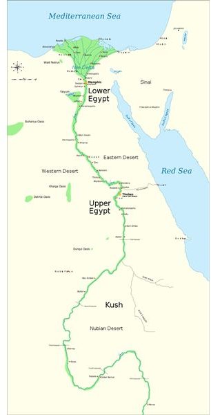
The Land of Ancient Egypt
Ancient Egypt was divided into 4 different areas of land.
The labels “Upper” and “Lower” were given in relation to the flow of the Nile, whose current flowed from south to north and emptied into the Mediterranean Ocean. The river valley of Upper Egypt is actually located in the southern area of the country.
Lower Egypt is located in the northern section of the country and stretches from modern-day Cairo to the Nile Delta at Alexandria. It was dubbed Lower Egypt because it is further from the Nile’s source.
Other times, the Ancient Egyptians differentiated their land by referring to it by its two vastly different climates. The Red Land was the name given to the dry desert that lay on either side of the Nile River. The Nile Valley, on the other hand, was often called The Black Land, for the rich, fertile soil that resulted from the annual Inundation.
Nomes in Ancient Egypt
Both Upper and Lower Egypt were further divided into smaller provinces called nomes, which were ruled by Nomarchs, who were either appointed by the Pharaoh while other times, their position was inherited.
Each nome had its own separate symbol. Different gods (often multiples ones) were worshipped within these various provinces, with the capital city taking on the role of becoming the religious and economic center.
With 22 nomes in Upper Egypt and 20 in Lower Egypt, the boundaries often changed as the land around the Nile was cultivated and its branches changed course.
However, these provinces played an important role in the economic role of Ancient Egypt, as well as providing strategic points for the Egyptian army to defend its people.
Archeology & Geography
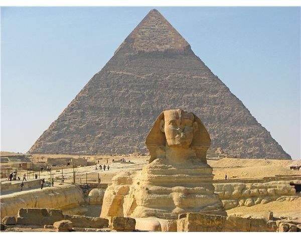
Ancient Egypt is well-known for being home to many of the ancient world’s most treasured archeological monuments , such as the Great Pyramids and The Sphinx.
Egypt’s geography played an important factor in the types of monuments built during ancient times.
Because of its location in the desert, supplies needed to be shipped into Egypt for the construction of its various statues, monuments and pyramids.
Limestone was excavated from rock quarries thousands of miles away, lending itself to a hard life for the thousands of labourers who were recruited from many of Egypt’s small provinces and spent many years toiling in the harsh climate.
Photo: Mohamed Aly
More Articles
To find out more about the geography of Ancient Egypt, read these articles:
Sources
Ancient Egypt Nomes: https://www.ancientegyptonline.co.uk/nomes.html
Tour Egypt: https://www.touregypt.net/featurestories/map-of-egypt.htm
Ancient Egypt Online: https://www.ancientegyptonline.co.uk